


Product Details
+
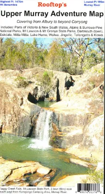
Coverage extends from Albury / Wodonga to Corryong and from the Murray River, south to Mitta Mitta, Dartmouth Village, Glen Dart and Running Creek. The map includes Mount Granya State Park, Lake Hume,mbtg Mount Lawson State Park, Burrowa – Pine Mountain National Park, Mount Mittamatite, Wabba Wilderness plus state forest around Cravensville, Eskdale, Mitta Mitta and Nariel.
Scale is 1:100,000.
Roads and tracks have been carefully field-checked in 2006 / 2007 using GPS technology.


")


![Scanstrut Rail Mount f/GPS or VHF Antenna [RA-01]](https://www.outdoornavig.shop/image/scanstrut-rail-mount-fgps-or-vhf-antenna-ra-01_aVZAyI_285x.webp "Scanstrut Rail Mount f/GPS or VHF Antenna [RA-01]")


